
 |
|
 |
|
|
|
The area known as Oxford Center was built up along the highway of the Old Oxford Turnpike. This was chartered in 1795, and was for half a century one of the principal highways in the state, being a line from New Haven to the Southbury-Woodbury districts.
The highway served as a stage coach route and regular freight teams and farmers used the road to take produce to the city market or towns in the Naugatuck valley.
A toll house was established on the highway, on the east bank of the Little River, about a quarter of a mile below Oxford Center, proper, in the area where now stands Devaux Gas Station.
The central part of the town was considered to have the poorest land in town, from an agricultural standpoint.
In 1838, J. W. Barber said of the Oxford Center, in describing an engraving of his,:"The elevation seen in the background is called 'Governor's Hill,' so named, it is said from its being principally owned, many years since, by a Mr. Bunnel, who was considered by his neighbors as a lordly kind of a personage, and had considerable to do with the law, being engaged in many law-suits for the support of his real or imaginary rights. From the important and consequential airs he assumed among his neighbors, he probably received the designation of 'Governor'."
"About one mile south of the central part of the town is a remarkable mineral spring; called "the Pool" from the circumstance of the waters being efficacious, and much used for the cure of salt rheumand other complaints. Once a month a yellowish scum will collect upon the surface of the water, which in a few days will run off, and leave the pool perfectly clear. In the coldest weather this spring never freezes; in the driest season it is as full as at other times."

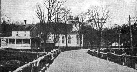
Above is a postal card photograph of Oxford Center, looking north, taken at about 1900. The Episcopal Church is shown; the adjacent house which is presently the rectory of the church, was not at that time owned by the parish.
|
|
|
 |
|
 |